
Wild Scotland - new map published by SNH


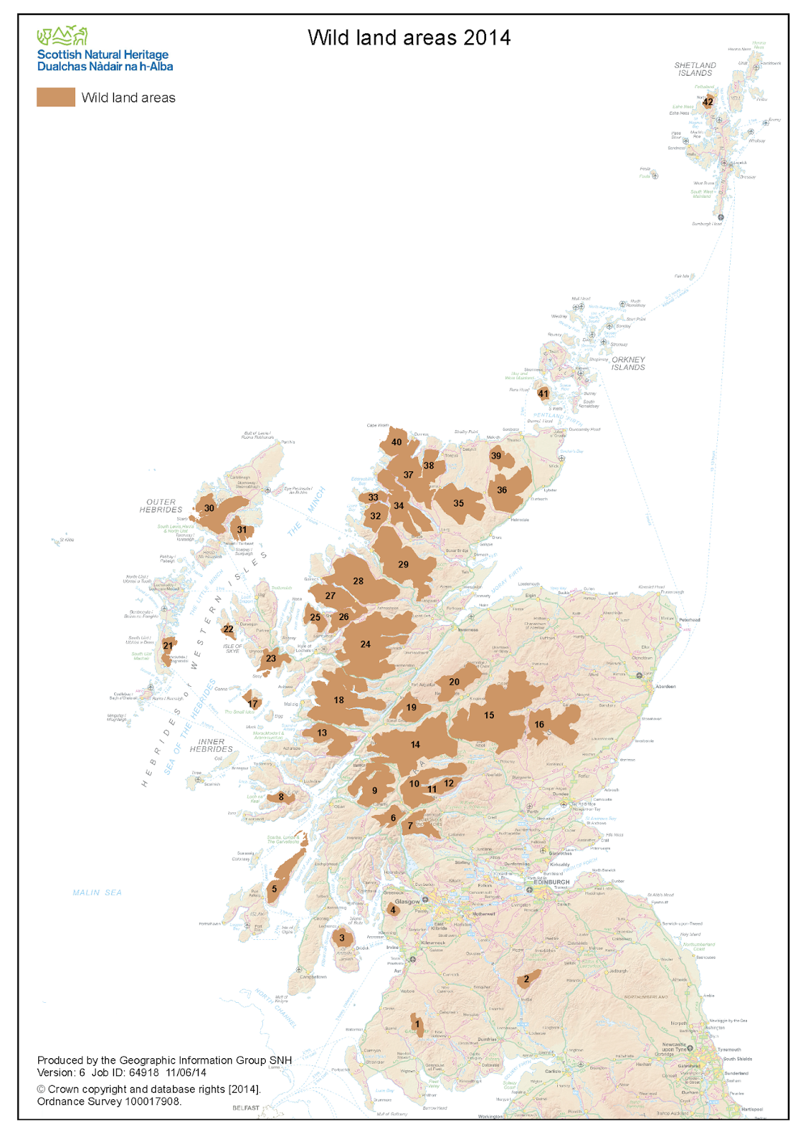
Scottish Natural Heritage has published its 2014 map of Wild Land Areas of Scotland - designated areas of coast, upland and undeveloped land - or 'wilderness' - which should be considered inviolate. Some of the areas are notably under protection via bodies such as National Parks, the John Muir Trust, or the National Trust and other private bodies, but the worrying note is that since the draft map was published in 2013, 0.8% of wild land has been developed (20.3% down to 19.5%). If it continued at that rate we'd have no wild land left by 2039 . . .

The conclusions of the report and mapping were as follows:


  • The concepts of wildness and safeguarding of wild land enjoy strong support from the public and many stakeholders in Scotland. Areas of wild land are widely acknowledged as important assets, providing a number of significant ecosystem services that support a range of social and economic benefits and outcomes. 
  • Despite the inherent subjectivity of the concept, the physical qualities most strongly associated with wildness and identification of wild land can be mapped in a robust and repeatable way through applying a systematic and transparent methodology. 
  • A map of wild land areas important in the national context is required in order to provide greater clarity to all stakeholders and better inform decisions affecting them. 
  • The name ‘Core Areas of Wild Land’ resulted in some confusion and we therefore propose the use of the nomenclature of ‘Wild Land Areas’. We suggest that the application of this name should be restricted in use to those areas shown on the map. 
  • The map of wild land areas should be considered a useful and important strategic tool in decision making. Its application will be enhanced by two further pieces work that are being developed during 2014-15: descriptions of the character and nature of each of the areas, and revision of our interim guidance on assessing the effects of proposals on wild land which allows a case by case assessment of proposals in relation to wildness character.

I like the fourth point that there s no such thing as a 'core' area of wildness, it either is or isn't wild. However, there are some who may consider the issue of remoteness and wildness much more complex. For example, what about wild urban areas and brownfield sites (landlocked 'waste' land, no matter how small); underwater wildness; community (commons) wildness versus private, estate-managed (landlorded) wildness . . . it's a complex issue but it's welcome seeing SNH producing a map which can be used practically to inform major policy decisions on what we should just leave alone if we can.

Popular posts from this blog

Vertical Landscapes: Exploring Glasgow's Hidden Bouldering

With the new guide to Glasgow Bouldering forthcoming, and with the last two years spent scouring our local landscapes for vertical diversion, many of us discovered a closer, more nuanced appreciation of climbing and how it helps maintain mental wellbeing as much as physical. The big mountains and wilderness landscapes were for the first time excluded from access and our pandemic taught us all to appreciate the landscapes on our doorstep. Even the urban world has its own small wildernesses and landscapes to immerse ourselves in for a while. For me, the daily walk in lockdown occasionally became a hunt for an esoteric piece of rock spied on the OS map or Google Earth. Rumours of boulders and mythologies of obscure rock were hunted down to help feed a hunger for the vertical. Even Dumbarton Rock was out of range, lying outside of the Glasgow City boundary. It's a venue which famously makes the blood run cold, with fiercely exposed overhanging routes, highball boulder problems and cl

The Lost Township of Grulin on Eigg

‘The Stony Place’ as it translates, the archaeological notes on the RCAHMS database for Eigg, state baldly the lost humanity of Grulin as early as an 1880 OS survey map: ‘…eighteen unroofed buildings, six enclosures and a field-system’. Now a scheduled monument and memorialised as a ‘depopulated settlement’, though it is not obvious if the verb is passive or aggressive, Grulin Uachdrach (Grulin Upper) is, like Hallaig on Raasay, a place of violent silence and resonance. Who lived here and why was the site abandoned? If it were not in Scotland, suspicions might fall to the climate, remoteness and apparent unsustainability of the stony place, a rabble of large rocks under the steep slopes of An Sgurr, but the carefully constructed walls tell us it was once a thriving township – the kilns, folds and blackhouse walls integrated with the giant boulders such as Clach Hosdail. In 1853 the whole of the village of Grulin, both upper and lower, housed fourteen families who were forced to l

Timeline Walks of Scotland #Hallaig to Screapadal on Raasay

'Tha tìm, am fiadh, an coille Hallaig ...' Hallaig - the lost village of Raasay - is a powerful place. Arguably, it has become a shibboleth for the soul of Gaelic culture. To visit it, to just be there momentarily and feel the resonance of the place, is to know the fragility of place and home, of how kinship can be shattered and how loss can invade a land. Aptly, Hallaig is now a site of pilgrimage for those who value the universal lessons of history.  There are t errible reasons for the loss of Hallaig. Its silent mouths of abandoned shielings, the dumb sheep meandering amongst the ruins, whisper with Sorley MacLean's poetry. The place misses the sounds of day-to-day community, and all around the woods and burns and slopes this tough but rich landscape once made this a hardy paradise under the eastern cliffs of Raasay. Facing east to the dawn and overlooking the peninsula of Applecross and the berry-dark depths of the Inner Sound, the walk to Hallaig leads quietly