
Limestone on Arran

From Sannox to Lochranza Coastal walk

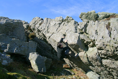
There is precious little limestone climbing in Scotland - the huge massif in Assynt has some potential, but at least in terms of bouldering there is something closer to home. I checked the geology map of Arran, which looks like a dartboard of colours around a swollen granite bullseye, and on the outer rim on the north east is a long coastal strip of limestone between Sannox and Lochranza. This is a mini-wilderness, with no road and the trail leads far away from the tourist strip of the Arran loop road.

The 4 to 5 hour walk is fascinating in itself, the trail leading through old red sandstone to the Fallen Rocks which are a jumble of conglomerate boulders with maybe some potential, climbing the hill in a monolithic jumble to the giant crag of Creag a Chais (rock of cheese!). However, things change suddenly to limestone and just past the fallen rocks on the left is a sandstone/limestone sandwich forming a steep roof with some great looking problems once cleaned and out of winter dreep. A good spot for summer camping and bouldering.

At the picturesque Laggan cottage further along past Millstone Point there is another good clean roof of limestone beside the cottage, with a few boulders uphill of this providing some good sport.

From Sannox to Lochranza Coastal walk

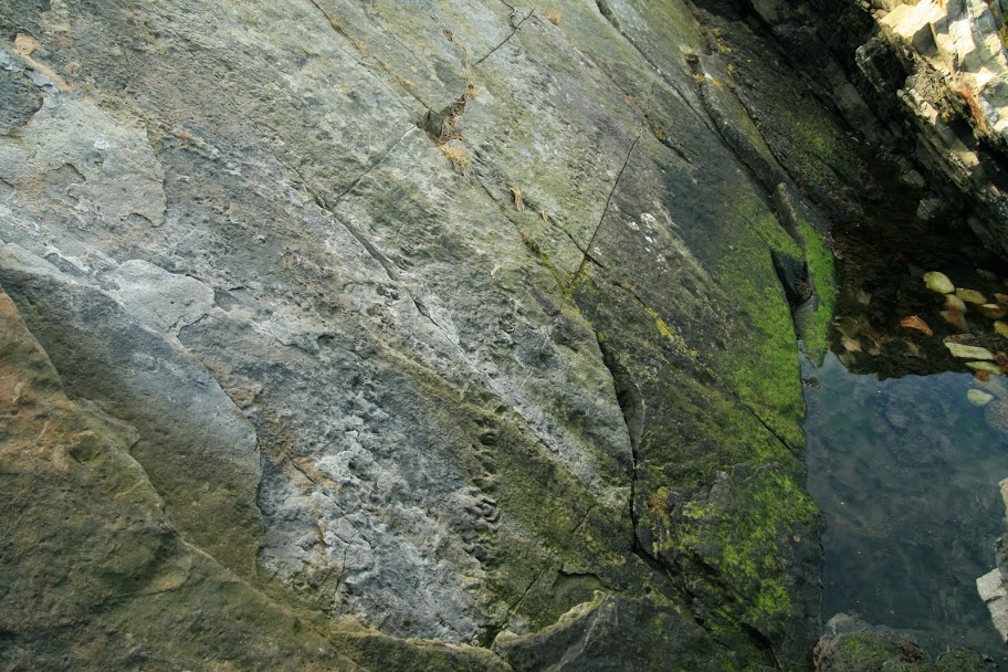
Make sure you head along to the ruins of the old salt mine to check out the fossilised footprints of a giant centipede (300m years old from the Carboniferous age of monsters) - it was 2m long with a girth over a foot across: the tram trail of this beast is impressive, certainly not something you'd want to come eye to eye with on topping out...

Arthropleura Giant Centipede

At the Ossian's Cave area there is a good sandstone boulder on the turf by the shore with some nice straight-up problems and a roof or two.

The path meanders around the Cock of Arran and through the labyrinth of giant scree at An Sciodan, finally depositing you on the pleasant pebble beach of the Fairy Dell. One good conglomerate wall and a sea boulder provides a girdle DWS over aquamarine waters.

By the time you hit Lochranza, the long loop round to the bus-stop is a slog and there was no pub/shop open for refreshment... time your bus run back to Brodick carefully!


View Sannox to Lochranza Coastal Walk in a larger map

Popular posts from this blog

Vertical Landscapes: Exploring Glasgow's Hidden Bouldering

With the new guide to Glasgow Bouldering forthcoming, and with the last two years spent scouring our local landscapes for vertical diversion, many of us discovered a closer, more nuanced appreciation of climbing and how it helps maintain mental wellbeing as much as physical. The big mountains and wilderness landscapes were for the first time excluded from access and our pandemic taught us all to appreciate the landscapes on our doorstep. Even the urban world has its own small wildernesses and landscapes to immerse ourselves in for a while. For me, the daily walk in lockdown occasionally became a hunt for an esoteric piece of rock spied on the OS map or Google Earth. Rumours of boulders and mythologies of obscure rock were hunted down to help feed a hunger for the vertical. Even Dumbarton Rock was out of range, lying outside of the Glasgow City boundary. It's a venue which famously makes the blood run cold, with fiercely exposed overhanging routes, highball boulder problems and cl

The Lost Township of Grulin on Eigg

‘The Stony Place’ as it translates, the archaeological notes on the RCAHMS database for Eigg, state baldly the lost humanity of Grulin as early as an 1880 OS survey map: ‘…eighteen unroofed buildings, six enclosures and a field-system’. Now a scheduled monument and memorialised as a ‘depopulated settlement’, though it is not obvious if the verb is passive or aggressive, Grulin Uachdrach (Grulin Upper) is, like Hallaig on Raasay, a place of violent silence and resonance. Who lived here and why was the site abandoned? If it were not in Scotland, suspicions might fall to the climate, remoteness and apparent unsustainability of the stony place, a rabble of large rocks under the steep slopes of An Sgurr, but the carefully constructed walls tell us it was once a thriving township – the kilns, folds and blackhouse walls integrated with the giant boulders such as Clach Hosdail. In 1853 the whole of the village of Grulin, both upper and lower, housed fourteen families who were forced to l

Timeline Walks of Scotland #Hallaig to Screapadal on Raasay

'Tha tìm, am fiadh, an coille Hallaig ...' Hallaig - the lost village of Raasay - is a powerful place. Arguably, it has become a shibboleth for the soul of Gaelic culture. To visit it, to just be there momentarily and feel the resonance of the place, is to know the fragility of place and home, of how kinship can be shattered and how loss can invade a land. Aptly, Hallaig is now a site of pilgrimage for those who value the universal lessons of history.  There are t errible reasons for the loss of Hallaig. Its silent mouths of abandoned shielings, the dumb sheep meandering amongst the ruins, whisper with Sorley MacLean's poetry. The place misses the sounds of day-to-day community, and all around the woods and burns and slopes this tough but rich landscape once made this a hardy paradise under the eastern cliffs of Raasay. Facing east to the dawn and overlooking the peninsula of Applecross and the berry-dark depths of the Inner Sound, the walk to Hallaig leads quietly