Timeline Walks of Scotland #Hallaig to Screapadal on Raasay

Hallaig - the lost village of Raasay - is a powerful place. Arguably, it has become a shibboleth for the soul of Gaelic culture. To visit it, to just be there momentarily and feel the resonance of the place, is to know the fragility of place and home, of how kinship can be shattered and how loss can invade a land. Aptly, Hallaig is now a site of pilgrimage for those who value the universal lessons of history. There are terrible reasons for the loss of Hallaig. Its silent mouths of abandoned shielings, the dumb sheep meandering amongst the ruins, whisper with Sorley MacLean's poetry. The place misses the sounds of day-to-day community, and all around the woods and burns and slopes this tough but rich landscape once made this a hardy paradise under the eastern cliffs of Raasay.
Facing east to the dawn and overlooking the peninsula of Applecross and the berry-dark depths of the Inner Sound, the walk to Hallaig leads quietly along a broad walkway under Beinn na Leac to the southern promontory of Rubha na' Leac, from where a series of dramatic Jurassic sandstone cliffs and headlands diminish to the northern shielings of Screapadal, where the story of Hallaig is echoed painfully.

Hallaig was named as a Norse settlement, the 'holy bay', but it would have been a fertile patch of land long before that and medieval run-rigs suggest earlier habitation. Standing by the dedicatory cairn to Sorley MacLean, the broad sheltered bays lap up against steep cliffs. Burns tumble off cliffs into the ocean in great white horse-tails. Perched above the cliffs and slopes are the greener swathes of the farmed land, surrounded by thickets of alder and birch.
Hallaig is first named in print in a charter of 1596, specifically as a place of human settlement. By 1846 there was a total of 28 recorded houses around Hallaig but by 1871 there is only one shepherd and his family recorded*. What happened in the those few decades is a tale told all over the Highlands: land cleared for the 'new economy' of sheep farming, while the famines and potato blight of the 1840s added to the exodus. The feudal estate system and its imbalanced powers of laird and tenant allowed for the easy de-patriation of lands and expulsion, what we would now call ethnic cleansing. The reasons for doing so were couched in the blase terms of 19th century popular economics, ignoring both natural and human ecologies of place for a blanket profit system. The argument for the clearances can be understood in almost every case as a decision of economy by empowered individuals rather than communities. The older chief/clan system which valued kinship and its support (especially in times of war) could easily be transitioned to a more selfish laird/tenant relationship where the exploitation of the feudal land rights became more profitable than the idea of maintaining community.

To understand the harshness of this land, the rugged walk from Fearns to Brochel Castle, along the eastern coast of Raasay, takes around seven hours of hard negotiation with vegetation, rocks, gorges, burns, tidal shores and steep slopes. The first part of the walk, from the road-end at North Fearns, leads along the pleasant access track of An Leac, along which so many disappeared would have walked to and from Inverarnish and Clachan. The sunny track, under canopies of old willow and rowan trees, leads to the headland of Rubha na' Leac and allows the first spectacular views north along the Jurassic cliffs of eastern Raasay. A cairn to Sorley MacLean subtly announces the territory of remembrance that lies ahead. Ahead, in the silent lee of larger cliffs, the Hallaig burn tumbles noisily off a headland upon which birch, alder and hazel woods cling to crumbling cliffs and gorges. The path darkens and weaves past a silent ruin and on through trees tattooed with vibrant green lungwort.

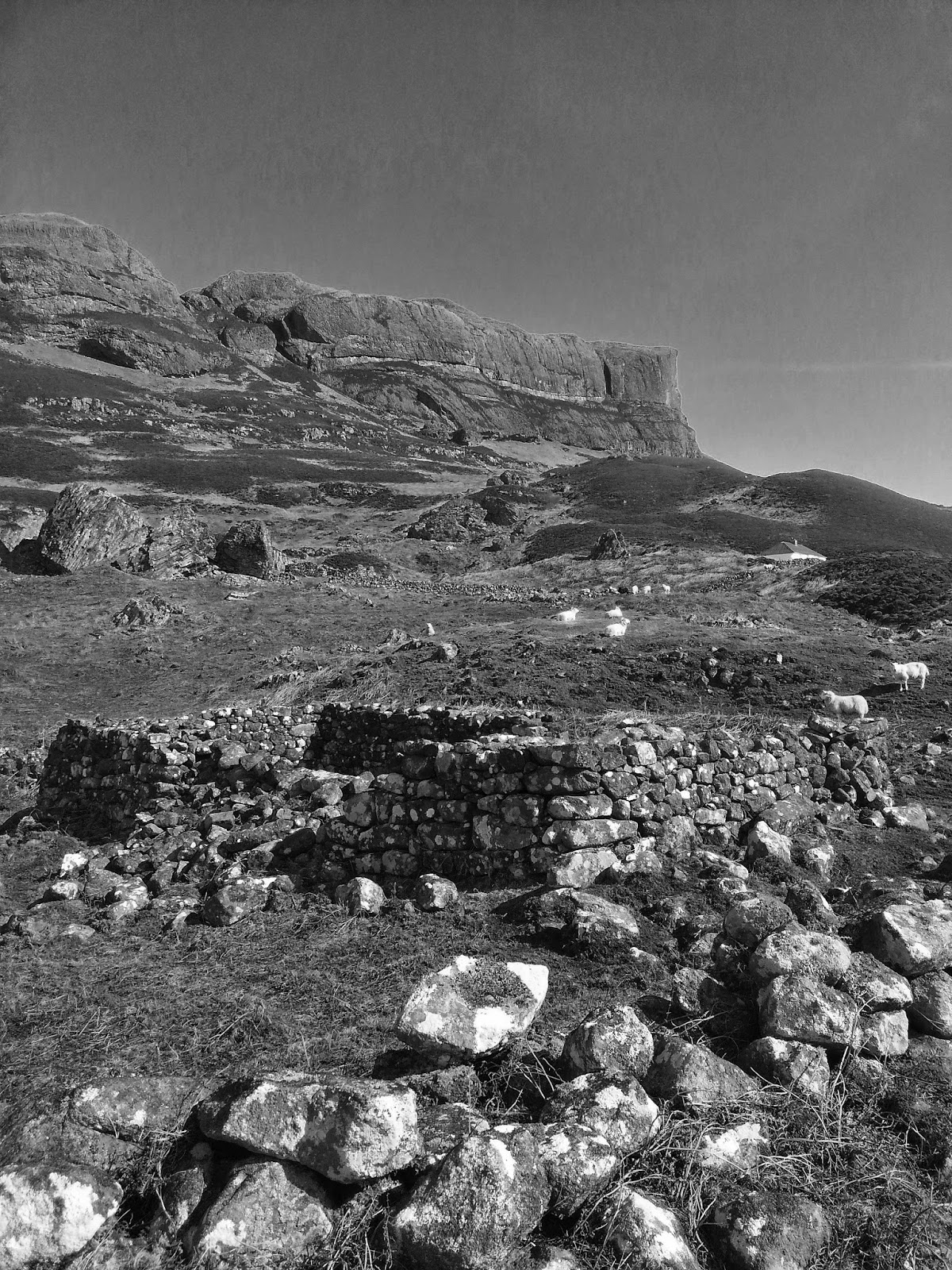
After crossing the burn the path weaves through a patch of coppiced birch, then opens out onto faint run-rigged slopes now matted with sheep-bitten turf. A walled sheep enclosure, which was built from the evacuated ruins of the Hallaig homes, forces you up and around the slopes to the remaining evidence of older communities. One particular complex of shielings, tucked into a sheltered mezzanine under the 'pass of Hallaig', showcases the architectural subtlety of the homes. Each house has a low wall to support now-vanished thatch roofing and at each corner the walls curve with dense rounded dyking, with an intricate jigsaw of carefully-selected stones, echoing an era of skill and care and kinship with the environment. The older natural laws of living on the land are built intrinsically into this fabric and there are no modern scripts on ecology and sustainability more telling than a Hallaig stone wall.


What lies ahead is a strenuous and sometimes claustrophobic walk under spectacular cliffs encrusted with what could only be called 'vertical Atlantic rainforest'. Hours are lost tracking the best way along this shore, occasionally on the tideline, occasionally embedded in bracken, boulder-fields and treacherous gullies. It is a struggle to make any headway in summer and best considered out of bracken-season. High above, the remarkable architecture of the pinnacles and cliffs echoes to the cry of both Golden and White-tailed Eagles, and the flora continually surprises with patches of primitive spore-spread flora such as ferns, horsetails and spleenworts. The sandstones on the shore are imprinted with Jurassic scallops, squid and tubeworms, and the sudden thump of heavy dinosaurs would not be a sound amiss amongst this ancient landscape.

Eventually the giant boulder-field south of the Screapadal ruins is met, with easier sheep-paths meandering into the fertile slopes of the older community lands north and south of the An Leth-allt burn. The largest boulder by the shore, with a caved underbelly, is known on the map as An Eaglais Bhrèige, which translates roughly from the Gaelic as 'the false church'. This is based on old folk-tales of Taghairm or pagan ceremony, easily appropriated as 'devil-worship'. The boulder cave does form a natural arch and altar and is now home to a hard bouldering rock climb by Scotland's most prolific modern rock climber Dave MacLeod, in the ancestral land of MacLeods, and very much a performed mark of respect, a tip of the hat as it were.
Modernity creeps back into the walk with mariner marker poles and spruce forestry, leading to a a landrover track back to the base of Calum's road and Brochel castle. Leaving a vehicle or bike at either end of this walk is a piece of advice worth taking, as the return to Inverarnish is a tale of weary feet, even if the mind is lightened and enriched.
The landscapes featured in this walk have been immortalised in many Sorley Maclean poems, but Hallaig is perhaps the most resonant. His words are a guttural Gaelic roll of keening, of remembrance, of loss and outrage:
‘Time, the deer, is in the wood of Hallaig’
The window is nailed and boarded
through which I saw the West
and my love is at the Burn of Hallaig,
a birch tree, and she has always been
between Inver and Milk Hollow,
here and there about Baile-chuirn:
she is a birch, a hazel,
a straight, slender young rowan.
In Screapadal of my people
where Norman and Big Hector were,
their daughters and their sons are a wood
going up beside the stream.
Proud tonight the pine cocks
crowing on the top of Cnoc an Ra,
straight their backs in the moonlight –
they are not the wood I love.
I will wait for the birch wood
until it comes up by the cairn,
until the whole ridge from Beinn na Lice
will be under its shade.
If it does not, I will go down to Hallaig,
to the Sabbath of the dead,
where the people are frequenting,
every single generation gone.
They are still in Hallaig,
MacLeans and MacLeods,
all who were there in the time of Mac Gille Chaluim:
the dead have been seen alive.
The men lying on the green
at the end of every house that was,
the girls a wood of birches,
straight their backs, bent their heads.
Between the Leac and Fearns
the road is under mild moss
and the girls in silent bands
go to Clachan as in the beginning,
and return from Clachan,
from Suisnish and the land of the living;
each one young and light-stepping,
without the heartbreak of the tale.
From the Burn of Fearns to the raised beach
that is clear in the mystery of the hills,
there is only the congregation of the girls
keeping up the endless walk,
coming back to Hallaig in the evening,
in the dumb living twilight,
filling the steep slopes,
their laughter a mist in my ears,
and their beauty a film on my heart
before the dimness comes on the kyles,
and when the sun goes down behind Dun Cana
a vehement bullet will come from the gun of Love;
and will strike the deer that goes dizzily,
sniffing at the grass-grown ruined homes;
his eye will freeze in the wood,
his blood will not be traced while I live.
NOTES
Geology of Raasay Map by Morton & Baird
Gaelic Place Names:
Screapadal - the rough/scabbed dale
Hallaig - from the Norse 'Heilag Vik' or Holy Bay
Cadha Carnach - Pass of the Stones
Creag nan Cadhaig - Crag of the Passes
Beinn na Leac - Hill of the Ledge
Dun Caan - The White Fort
Druim an Aonach - The Ridge of the Moor
Creag na Bruaich - the Crag of the Border
Beinn a' Chapuill - Hill of the Horse
Carn Mor - the Great Cairn
Eaglais Briege - the False Church [In the Place-Names of Skye (Alexander Robert Forbes, Published by Alexander Gardner, Paisley, 1923) this is quoted as: 'Eaglais Bhreugach The false or lying church. From a rock, like a church, on East-side, Kilmuir. See Buachaille Breige. This rock, also known as An Eaglais Bhrèige, the church of the lie or falsehood, has been described as a cave called “the make-believe cave church,” from what was termed an altar beside it in the shape of a huge boulder whereon Clann ’Ic Cuithen performed an awful pagan ceremony of Taghairm, gathering summons (see N.G.P.), vulgarly rendered in English, “ giving his supper to the devil,” and which consisted of— if all tales be true— roasting poor cats alive; this clan, or sept (said now to be absorbed in the Clan Donald), never bore a good reputation, a rhyme referring to them and others of a like kidney being: Clann 'Ic Cuithen chuir nam briag, Clann 'Ic Cuithen chuir an t-sodail; Clann 'Ic Mhannain chuir na braidè, Ged nach b'fhaid iad na (no) cas biodaig (Clan MacOoian, thievish experts, Clan MacOoan, quick to flatter, Clan Buchanan,* theft promoters, Though as small as shaft of dagger!) ... The word taghairm means primarily the gathering summons of a clan to battle; in connection with the above ceremony, it meant a gathering summons of evil spirits, an ancient mode of divination said to be one of the most effectual means of raising the devil ...']
* Landscapes of Clearance: Archaeological and Anthropological Perspectives, edited by Angele Smith, Amy Gazin-Schwartz